Hybrid Scanning Used to Document New Medical Office

Lidar News Blog Feature: September 15, 2021
A guest post from TruePoint Laser Scanning.
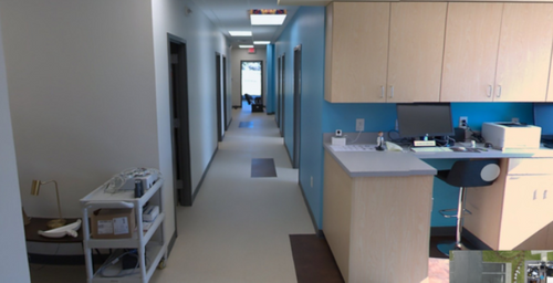
An internal medical practice near Birmingham, Alabama, US commissioned a state-of-the-art 3,500 sq ft office. The architect designed the building in 2D CAD software, and the drawings were used extensively by multiple trades throughout the building process, but it took a hybrid scanning approach to deliver the 3D models that were needed.
So far so good, but here’s the problem: The client needed more information than the 2D drawings could offer. They needed a colorized, accurate 3D data set, which would reflect all architectural and structural elements, as well as the floor plan as it was actually built. They needed this data set for a wide variety of high-value tasks, including arranging on-going facilities maintenance and operations, and planning future additions and renovations.
On top of that, the client had one more request. They needed the 3D data set to be colorized and include hi-definition color photos crisp enough to use in their marketing materials.
What the Doctor Ordered
The client hired the talented crew at TruePoint Scanning to capture these digital assets. TruePoint’s regional manager for the southeast, Andy Foshee, says the team attacked the project with a hybrid approach. They captured the interior using NavVis VLX, a wearable mobile mapping system that allowed them to scan as they walked. Then, they captured the building exterior using the Leica RTC360 3D Laser Scanner. At the end of the workflow, they registered the data sets together to produce a single point cloud.
Foshee says one of the primary reasons TruePoint picked NavVis VLX for this project is the ease of capturing the HD imagery the client required. “With NavVis VLX, you’re already walking through the areas you want to capture,” says Foshee, “and you can just press a button to take your HD photos manually. That means we could pick and choose where in the building to snap and get the images the client needed.”
A Short Appointment
Since NavVis VLX offers the ability to scan on the move, this means it offered our client another benefit: speed. “We had to scan the building off hours so we wouldn’t interfere with normal business operations,” says Foshee. “But since NavVis VLX collects data faster than other scanners, this wasn’t a problem. We were able to capture the 3,500 sq ft office in one evening shift—I was finished with the interior in about 30 minutes, and the rest within 2 hours. The whole workflow is shorter, and this got us off site sooner,” he adds. “I’d say that, on average, NavVis VLX cut our time on site by 50%.”
Prognosis: Excellent
In the end, TruePoint delivered a single colorized point cloud and 40 HD images for the 3,500 sq ft office. The company uploaded all of these digital assets to NavVis IndoorViewer for easy access from any standard web browser on a computer, tablet, or phone. This will enable stakeholders to download the point cloud data and imagery as needed for use in offline CAD or BIM platforms on future projects. TruePoint also used IndoorViewer to distribute the HD images to the client.
For the complete article from TruePoint Laser Scanning on hybrid scanning CLICK HERE.