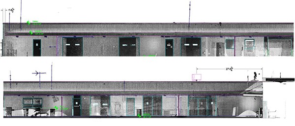
2D AutoCAD drawings of an elevation view
Case Study: Outdoor Baggage Processing Area
Location: North Canton, Ohio
Task: Utilize LIDAR technology to laser scan the exterior of three building facades surrounding an outdoor baggage processing area of approximately 22,000 square feet. Building columns and significant features were the focus of the scan in order to analyze how a new structure would interact with the existing building.
Challenge: The client was going to set a new structure to cover an open space and needed to determine proper clearances between existing structures and analyze load that would be placed onto the existing structure. In addition, the ground below the proposed structure had a sharp elevation change that would affect the placement of support columns in order to ensure the new structure aligns properly. The client was struggling to find a way to measure this using traditional field measurement techniques due to these varying surfaces and due to heavy vehicle traffic in this area.
Solutions: By utilizing 3D Laser Scanning, the entire exterior space was captured in just one day, including rooftop information such as existing HVAC systems – all while scanning from out of the way of the congested areas. After capturing the scan data from both ground level and rooftop, TruePoint was able to generate detailed section and elevation view drawings in a matter of days for the client to use in their bidding process. This allowed the contractor to have more information up front and a better understanding of the project, allowing the client to receive more competitive bid numbers.
Deliverables: Intensity Map Point cloud and AutoCAD files (.dwg file format) with a plan view and Section views of various areas showing lowest spot elevation on the ground and highest spot elevation of the building.
Added Value: TruePoint was able to mobilize in a matter of days and provide information prior to the bidding process. By scanning prior to the bid process, the client was able to send this information along in the bid package to provide prospective contractors with better information, which translates into more accurate price bids. In addition to the elevation and section views of the structure itself, ground topography could be analyzed as well and rooftop objects with elevations could be considered. TruePoint’s Scan Technician was able to work directly with TruePoint Engineers, Architects and technical professionals to ensure data captured was appropriate for the deliverables.
For 3d laser scanning of building projects in the greater Cleveland region please contact Zach Jones at 216-470-7262
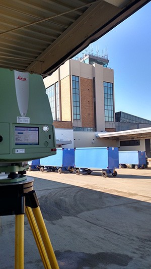
3D Laser Scanner capturing building structural features
